How To Find Your Property On FEMA’s Flood Insurance Rate Maps

What are FEMA flood maps?
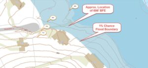
FEMA’s Flood Insurance Rate Maps (FIRMs) or just Flood Maps are provided after a flood risk assessment has been completed or updated for a community.  This study is known as a Flood Insurance Study.  The FIRM gives you the Base Flood Elevations (BFEs) and insurance risk zones in addition to floodplain boundaries.  The FIRM may also show a delineation of the regulatory floodway.

Once the “insurance risk zone”  (commonly referred to as the flood zone) is determined, actuarial rates, based on these risk zones, are then applied for newly constructed, substantially approved, and substantially damaged buildings.  FEMA uses these rates to determine the insurance rate you will pay for flood insurance

FEMA’s Digital Flood Maps

FEMA discontinued the production and distribution of paper flood maps in 2009 as part of its Digital Vision Initiative. This affected all the Flood Maps, boundary information, and study reports. However, clients can still view the products for free through their website or buy them in digital format.

To view these flood maps online, go to FEMA’s Map Service Center and key in your address (hi-lited area shown here) search for your home.  This will prompt you to then select the map that covers your area.  The Flood Maps are somewhat cumbersome to use online. It is best to go through the tutorial on the bottom right of the address search page for an easier and more effective use of the GIS map.

author avatar
Surveyor

More Posts

Surveying equipment set up on a construction site to ensure accurate topo surveys and reliable land development in Bowling Green
land surveying
Surveyor

Accuracy Levels in Topo Surveys: What’s Considered Reliable?

If you’ve ever tried planning a project, you already know how quickly things can get complicated. Permits, grading, drainage—it all depends on having the right information from the start. That’s why topo surveys are so important. They give you a clear picture of your land so engineers, contractors, and even

Read More »
Professional land surveyors in safety vests and hard hats using surveying equipment on a property site during ALTA surveys in Bowling Green
alta survey
Surveyor

How ALTA Surveys Protect Stakeholders in Real Estate

If you’ve ever tried to buy or sell property, you already know—it’s never just one person at the table. Buyers, lenders, title companies, builders, even attorneys all have a stake in the deal. And when that many people are involved, mistakes can get expensive fast. That’s why ALTA surveys are

Read More »
Surveyor performing a boundary survey in a Bowling Green,residential area to confirm property lines for HOA approval
boundary surveying
Surveyor

Why Your HOA Might Require a Boundary Survey

Living in a community with a Homeowners Association (HOA) in Kentucky comes with certain rules and responsibilities. One of those responsibilities may involve getting a boundary survey before you start certain projects. At first, this might seem like an unnecessary step. However, it actually protects both you and your neighborhood

Read More »
Louisville, Kentucky skyline and bridge over the Ohio River at sunset, showing areas where flood risk and elevation certificates may apply.
flood damage
Surveyor

Why an Elevation Certificate Matters

If you live in Kentucky, especially in flood-prone areas, you may need an elevation certificate. This certificate shows how high your property is compared to the Base Flood Elevation (BFE) set by FEMA. Knowing this can help you understand your flood risk and possibly lower your flood insurance costs. In

Read More »
Historic bridge in Bowling Green, KY — example of local infrastructure supported by drone surveying
land surveying
Surveyor

How Drone Surveying Supports Bridge and Highway Projects

In fast-growing areas like Bowling Green, KY, road and bridge construction is happening all around us. Whether it’s expanding I-65, improving traffic flow on Scottsville Road, or working near the Barren River, accurate land data is essential. That’s where drone surveying comes in — offering fast, detailed insights without slowing

Read More »
Historic rural property with large lawn near Bowling Green, KY, ideal for topographic survey planning
land surveying
Surveyor

How Topographic Surveys Help Solve Drainage Issues on Rural Land

If you live on rural land near Bowling Green, KY, you know that drainage issues can be a real headache. From soggy yards to erosion washing out driveways, it’s a common challenge in this part of Kentucky. That’s why getting a topographic survey before starting any major work on your

Read More »