How To Find Your Property On FEMA’s Flood Insurance Rate Maps

What are FEMA flood maps?
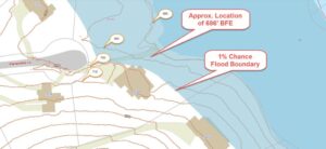
FEMA’s Flood Insurance Rate Maps (FIRMs) or just Flood Maps are provided after a flood risk assessment has been completed or updated for a community.  This study is known as a Flood Insurance Study.  The FIRM gives you the Base Flood Elevations (BFEs) and insurance risk zones in addition to floodplain boundaries.  The FIRM may also show a delineation of the regulatory floodway.

Once the “insurance risk zone”  (commonly referred to as the flood zone) is determined, actuarial rates, based on these risk zones, are then applied for newly constructed, substantially approved, and substantially damaged buildings.  FEMA uses these rates to determine the insurance rate you will pay for flood insurance

FEMA’s Digital Flood Maps

FEMA discontinued the production and distribution of paper flood maps in 2009 as part of its Digital Vision Initiative. This affected all the Flood Maps, boundary information, and study reports. However, clients can still view the products for free through their website or buy them in digital format.

To view these flood maps online, go to FEMA’s Map Service Center and key in your address (hi-lited area shown here) search for your home.  This will prompt you to then select the map that covers your area.  The Flood Maps are somewhat cumbersome to use online. It is best to go through the tutorial on the bottom right of the address search page for an easier and more effective use of the GIS map.
author avatar
Surveyor

More Posts

Land surveyor using tripod equipment under a starry night sky showing how a geomagnetic storm can affect GNSS accuracy during a boundary survey
boundary surveying
Surveyor

Solar Storms Can Throw Off Your Boundary Survey

The northern lights glowing over Kentucky last weekend were a rare sight. Social media lit up with photos from Bowling Green to Louisville as the sky turned pink and green. But while everyone admired the show, local surveyors were watching something else—their GNSS readings. A boundary survey relies on satellite

Read More »
Residential neighborhood with partially flooded homes illustrating the importance of an elevation certificate for flood risk and mortgage protection.
flood damage
Surveyor

Why You Need an Elevation Certificate Before Closing

If you’ve tried to buy or refinance a home in Bowling Green lately, you’ve probably heard the term elevation certificate more than once. It’s more than a formality—it’s verified proof of how safely your home stands above potential flood levels. And this week, that proof matters more than ever. Heavy

Read More »
Drone surveyors on a construction site using UAV equipment with drone flying overhead
land surveying
Surveyor

Drone Surveyors Face Shortages: How Crews Stay on Track

In the last week, surveyors online have been buzzing about a growing problem: drones breaking down with no replacements in sight. One post on Reddit described a surveyor who crashed his Phantom 4 Pro, tried to upgrade to a Mavic 3 Enterprise, and then discovered the drone was on backorder

Read More »
A licensed land surveyor measuring a home’s elevation to prepare a flood elevation certificate for lowering insurance costs
flood damage
Surveyor

Flood Elevation Certificate: Lower Your Insurance Costs

Big news hit the flood insurance world last week. A U.S community earned a major discount for its homeowners when FEMA raised its rating in the National Flood Insurance Program. Families there will now save up to 35% on their premiums. That’s a big win, and it made headlines across

Read More »
Land surveyor conducting a property survey in open karst terrain with rolling hills in the background
boundary surveying
Surveyor

Property Survey Guide: Protecting Against Sinkhole Risks

Buying or developing land can be exciting, but it also comes with unique risks. This part of Kentucky is famous for its rolling hills and underground caves, but it’s also known for sinkholes. That’s why a property survey does more than confirm your boundary lines—it helps protect you from surprises

Read More »
Drone land surveying aerial view showing residential properties and clear property boundaries for accurate land data.
land surveying
Surveyor

How Statewide Drone Land Surveying Is Changing Property Data

Have you ever wondered how surveyors measure land and property? Well, now they are using something pretty cool drone land surveying. In Bowling Green, a new statewide program is using drones to collect property data in a faster and better way than ever before. What Is Drone Land Surveying? Drone

Read More »