Kentucky’s distillery properties rarely fit the mold of a single commercial building on a single lot. A working distillery campus can include a rickhouse row, a bottling plant, a visitor center, employee parking, and access roads that grew over decades as the business expanded. Buying one of these properties means buying a group of connected parts, not one clean parcel.
Some campuses formed through separate land purchases over the years. Others were built on land assembled from several smaller tracts and later treated as one operation. Either way, the paper record and the property on the ground don’t always match up cleanly.
An ALTA title survey is the survey product commercial buyers and lenders rely on to get a clear, consistent picture of a property before closing. Current ALTA/NSPS standards address surveyed property made up of multiple parcels and require the surveyor to identify survey-related matters that cross or touch those parcels. For a distillery campus, that detail matters more than it would for a single-building purchase.
One Campus, Several Parcels: Why the Acquisition Footprint Matters
Before a buyer signs anything, they need a clear answer to a basic question: which parcels and improvements are actually part of this deal?
Distillery campuses often grew piece by piece. A company might have bought the original production site, then added an adjacent tract for a new warehouse, then picked up another parcel years later for parking or expansion. Each purchase came with its own deed, its own legal description, and sometimes its own set of recorded easements or restrictions.
When all of that gets sold as one operation, the buyer needs to see how the pieces fit together. Does the legal description in the purchase agreement actually cover every parcel that makes up the campus? Are there gaps between parcels, or overlaps? Do older deeds reference boundary lines that no longer match current fencing or pavement?
An ALTA title survey gives the buyer one consistent depiction of the surveyed property, tied to the title commitment, showing the parcels together and flagging the recorded matters that affect them. That consistency is the point. Instead of piecing together several old surveys and deeds on their own, the buyer gets one current picture built to a recognized standard.
From Production Buildings to Visitor Areas: Matching Improvements to the Survey
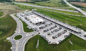
A distillery campus can carry a wide mix of physical improvements. Production buildings and aging warehouses sit alongside visitor centers, retail space, parking lots, loading docks, and internal roads connecting it all. Not every distillery has the same layout, but many operating campuses include some combination of these uses.
For a buyer, the question isn’t just what buildings exist. It’s whether those buildings, along with paved areas, fences, and other visible features, are accurately shown in relation to the property lines and to each other.
A parking area that was expanded years ago might now sit closer to a boundary line than the old site plan shows. A loading dock addition might extend past where an easement was originally drawn. None of this is unusual on a campus that has operated and grown over time. But a buyer evaluating the physical footprint of the acquisition needs to see it clearly, not guess at it from old drawings.
The survey shows what’s actually there and how it relates to the recorded property lines and matters. That’s different from a general explanation of what an ALTA survey covers. Here, the focus is on how a working, multi-building operation gets represented as part of one transaction.
The Access Network Behind a Distillery Acquisition
Access matters more on a campus than on a single lot, because different parts of the property often depend on each other to function. A public road might reach only part of the site, while other buildings rely on internal drives, shared entrances, or recorded easements to connect back to that road.
A survey can show where public roads touch the property, where recorded rights-of-way run across or near it, and where physical driveways and access points sit on the ground. If part of the campus relies on an easement across a neighboring tract, or grants access to a neighboring property in return, the survey can depict those features as recorded.
Reading and interpreting what those rights actually allow, and how they affect the buyer’s plans, is a job for the title company and the buyer’s attorney. The survey’s role is to show what’s recorded and what’s physically there, so those professionals have accurate information to work with.
When the Existing Campus Layout Meets the Acquisition Documents
Once the survey is complete, buyers face a practical question: does the campus as it exists on the ground match the property and title information they’ve been reviewing?
Sometimes it does, cleanly. Other times, the survey turns up a fence line that doesn’t follow the recorded boundary, a parking area that crosses onto an adjoining tract, or a building that sits partly outside the platted lot lines. None of this means the deal falls apart. It means there’s a discrepancy that needs attention before closing.
An ALTA survey doesn’t resolve title issues or zoning questions on its own. What it does is put the facts on the table. From there, the buyer, the title company, the lender, the attorney, and the surveyor can work out what the discrepancy means and how to handle it, whether that’s a title exception, a boundary line agreement, or something else specific to the situation.
Catching these questions before closing, rather than after, is the whole reason to compare the recorded documents against the current campus layout early in the process.
Scoping an ALTA Title Survey Around the Deal, Not Just the Property
Every ALTA survey should be scoped around the actual transaction, not treated as a one-size-fits-all product. That starts with reviewing the title commitment and understanding what the lender, title company, and attorney will each need to see on the finished survey.
This is where Table A comes in. Table A is the list of optional items an ALTA/NSPS survey can include beyond the minimum standard detail, and the parties to the transaction negotiate which of those items apply. Current ALTA/NSPS standards specifically allow for negotiated additional Table A items and require any modifications or additional items to be identified on the finished survey. For a distillery campus, that might mean requesting detail on zoning classifications, utility locations, or specific improvements tied to the buyer’s plans for the property.
Getting this scope right takes coordination. The buyer knows what they’re trying to accomplish with the property. The lender and title company know what their underwriting requires. The attorney knows what needs to be addressed in the purchase documents. The surveyor needs input from all of them early, not after the survey is already underway, to make sure the finished product actually answers the questions this specific acquisition raises.