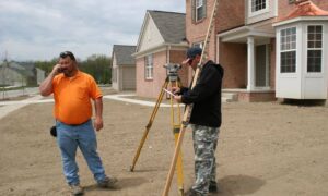
How to Find Someone to Survey Your Property Boundary Correctly

There are different reasons why somebody would need boundary surveying in their property. Often, this type of surveying is done if the owner of the property wants to legally place an item on the property such as a new structure or a fence.

A Licensed Land Surveyor

When hiring a land surveyor, you have to make sure that he is duly licensed by your state. A “licensed” land surveyor means he was able to complete his studies, passed all exams and is certified to perform specific types of land surveys.

Hiring a licensed land surveyor is especially important if there is a dispute over a certain area of a property as the court would be asking for the current boundary survey result as well as testimony from a licensed land surveyor. With this being said, you also have to make sure that the surveyor you’re going to hire can also stand as an expert witness in court.

Looking for a Licensed Land Surveyor

If your property has been surveyed before, it would be easier for you to contact that land surveyor again. This is the best option for several reasons; he already has all information about your property, making it easier for him to perform a new type of survey.

You can typically find your land surveyor’s information on the survey result given to you (if you’ve bought the property from somebody, for instance) or the result given to you by the surveyor himself.

If you don’t have the survey drawing, you can also check the markers put in place by the surveyor during the last survey done on your property. These markers, which looks like iron pegs or pipes, should have the surveyor’s license number/ name on it. You can use this information to find the surveyor online.

If you can’t find the surveyor who worked on your property before, or if the property has never been surveyed, you should easily find a land surveyor in your area (for a land surveyor in the Kentucky area, click here).

Important Points to Remember when Hiring an ALTA Surveyor

  • As mentioned, make sure that he or she is a licensed land surveyor.
  • He or she should have experience in performing alta boundary surveys. If you’re going to pay somebody, you’d rather have someone who has done it before, right?
  • Look for someone easy to talk to. Communication is very important when hiring a land surveyor. You see, surveying is more of an art than a science – this is why land surveying results vary. It’s important that your surveyor understand why you’re having the survey, what you’re going to use the results for and how soon you’ll be needing the results.
author avatar
Surveyor

More Posts

Solar flare erupting from the sun during a solar storm, showing the kind of space weather that affects GPS signals used in drone survey maps
land surveying
Surveyor

What Solar Storms Really Do to Your Drone Survey Maps

If you’ve ever scheduled a drone survey for a property project, you probably expect everything to be accurate down to the inch. Most days, that’s exactly what happens. However, recent headlines about powerful solar storms might make you wonder if the sun can actually mess with your survey. The short

Read More »
Licensed land surveyor using GNSS receiver in the field with teammate operating total station
land surveyor
Surveyor

How a Licensed Land Surveyor Works Without OPUS

When you hire a licensed land surveyor, you expect results that are accurate, reliable, and on time. But what happens when one of the main systems surveyors use—the OPUS (Online Positioning User Service)—suddenly goes down? That’s exactly what happened recently, and surveyors across the country turned to Reddit to vent,

Read More »
Aerial view of a suburban neighborhood flooded after heavy rain, showing why homeowners rely on a flood elevation survey to assess property risk
flood damage
Surveyor

Before Flood Maps Change: Get a Flood Elevation Survey

New buildings, roads, and power projects are changing southern Kentucky fast. But they’re also changing how water flows across the land. That’s why more people are now getting a flood elevation survey before they build or buy property. With floodplain maps expanding and more projects popping up nearby, knowing your

Read More »
Land surveyor using a total station along a new public path project for an ALTA Land Title Survey.
alta survey
Surveyor

New Projects Drive Demand for ALTA Land Title Survey

Kentucky just made headlines with a new project — the Boone County multi-use path contract. At first, it sounds like a simple trail for people to walk and bike on. But behind that news is something bigger that every builder, engineer, and property owner should notice: a growing need for

Read More »
Land surveyor using tripod equipment under a starry night sky showing how a geomagnetic storm can affect GNSS accuracy during a boundary survey
boundary surveying
Surveyor

Solar Storms Can Throw Off Your Boundary Survey

The northern lights glowing over Kentucky last weekend were a rare sight. Social media lit up with photos from Bowling Green to Louisville as the sky turned pink and green. But while everyone admired the show, local surveyors were watching something else—their GNSS readings. A boundary survey relies on satellite

Read More »
Residential neighborhood with partially flooded homes illustrating the importance of an elevation certificate for flood risk and mortgage protection.
flood damage
Surveyor

Why You Need an Elevation Certificate Before Closing

If you’ve tried to buy or refinance a home in Bowling Green lately, you’ve probably heard the term elevation certificate more than once. It’s more than a formality—it’s verified proof of how safely your home stands above potential flood levels. And this week, that proof matters more than ever. Heavy

Read More »